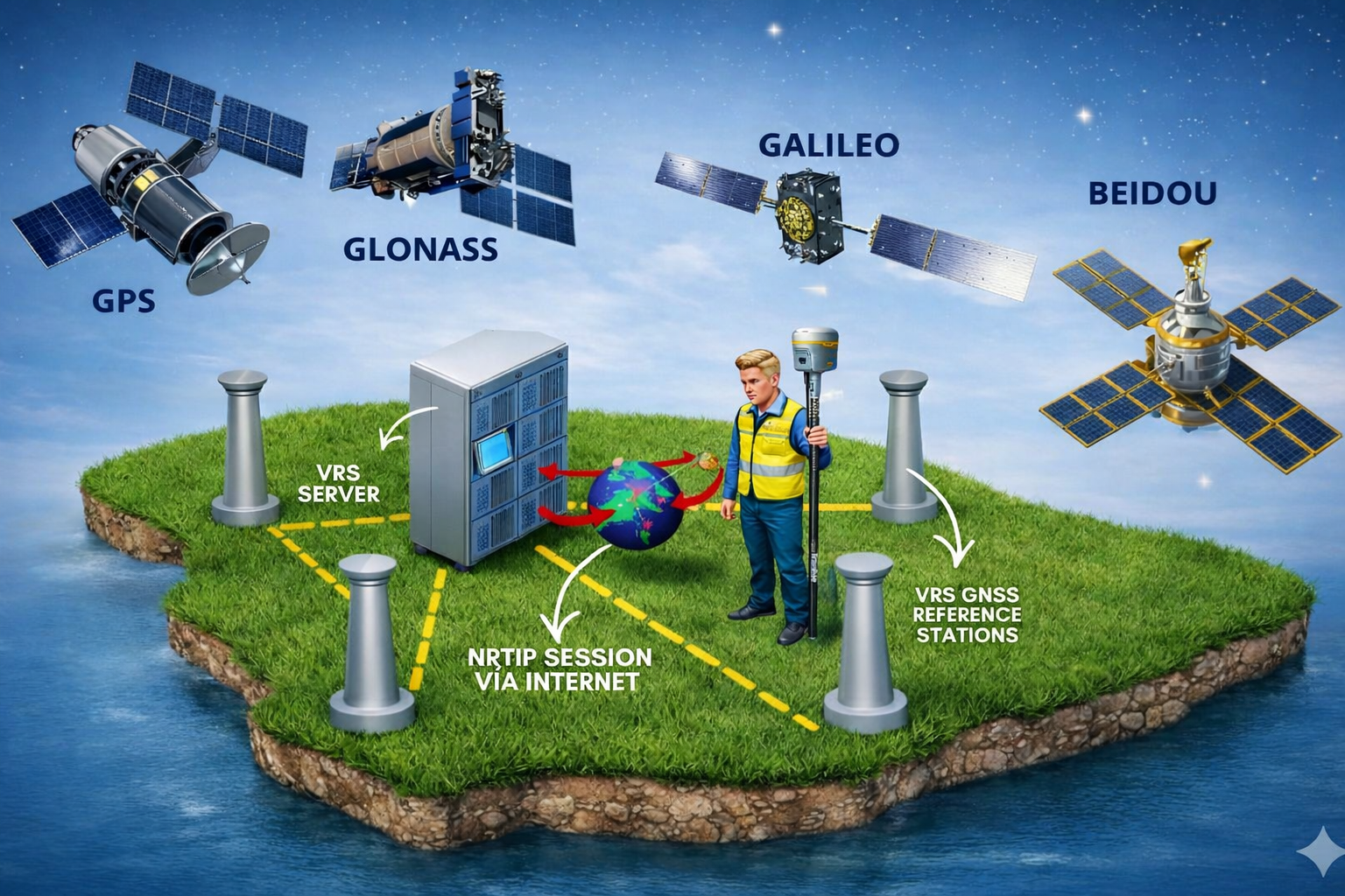
Our Virtual Reference Station (VRS) Systems includes eight GPS/GNSS receivers located around the island, providing island wide coverage and the only reliable service across Puerto Rico.
VRS Systems PR is the only company in Puerto Rico that owns and operates its system, as we have access to all of the sites where our GPS Receivers are located as well as all of the Internet access points, allowing us to guarantee the continuity of service, accuracy, support and reliability.
We are the only company that can offer a VRS solution, no other company has this capability, competitors software only provide RTK network solutions always attaching to the closest physical GPS Receiver not providing any benefits or advantages when comparing with typical radio RTK corrections.
VRS Systems PR Upgrade 2026
July 2022 – HLCM Group completed the upgrade of VRS Systems PR servers and software to include Galileo and BeiDou observation data. Powered by the Trimble Pivot™ Platform GNSS Real-Time Network software, VRS Systems PR in Puerto Rico now fully support GPS, GLONASS, and now, Galileo and BeiDou satellite systems. The addition of the Galileo and BeiDou constellations allow users to make use of more satellites, enabling more robust performance when working in harsh GNSS environments such as in urban canyons and under canopy.
As a four-constellation solution, VRS Systems PR will deliver improved real-time positioning performance for customers in Puerto Rico. VRS Systems PR is ideal for surveying, mapping and GIS, construction and agriculture professionals that require high-accuracy positioning in their workflows.
Adding Galileo and BeiDou observation data to VRS Systems PR provides significant benefits by enabling users to:
Check your GNSS receivers and if you would like to experience the full benefits of this upgrade please contact HLCM Group at 787-398-8852 and we can quote the upgrades needed for you to track Galileo, BeiDou, and triple frequency tracking options.
Trimble Pivot platform is the new foundation for infrastructure Apps. Various Apps support a wide and growing range of capabilities and may be combined to create complete solutions to the specific requirements of individual applications. Based on the latest server software technology, Trimble Pivot platform provides a robust and scalable framework to deliver exceptional system performance, enable flexibility in configuration and reduce the cost of operations. In this latest release, Trimble Infrastructure is excited to introduce two mobile apps: the Trimble Pivot Admin and the Trimble Pivot Field. Mobile device users can instantly download either mobile apps on their device, and access system information like health states, runtime information, and atmosphere conditions, at anytime and anywhere.
To learn more about the various Trimble Infrastructure apps that operate on the Trimble Pivot platform, visit the Trimble Pivot platform webpage
Trimble Pivot software provides the consistent performance you need to make sure that you are getting the most out of your network. Advanced protection such as protected memory areas and new algorithms for raw data analysis will provide the security that you need to prevent system crashes and unreliable data from disrupting your network.
Trimble VRS TM networks use RTK solutions from the Trimble Pivot software to provide high-accuracy, real- time kinematic (RTK) GNSS positioning for wider areas. A VRS network improves productivity while at the same time reduces costs, by eliminating the need to set up a base station.
Customers can testify our technologies are both intuitive and simple. Also is the most reliable signal in town. Join today and enjoy the benefits of the latest technologies like Pivot Platform. Trimble Pivot platform support a wide and growing range of capabilities and may be combined to create complete solutions to the specific requirements of individual applications. Based on the latest server software technology, Trimble Pivot platform provides a robust and scalable framework to deliver exceptional system performance, enable flexibility in configuration and reduce the cost of operations. Mobile device users can instantly access system information at anytime and anywhere.
We offer highly technical training services to surveying and mapping professionals in Puerto Rico and the Caribbean. Our offerings include: GPS/GNSS operation; GPS/GNSS processing techniques; GNSS, PPK, RTK, and RTK network (VRS) solutions; total stations; 3D laser scanning; mobile mapping; LiDAR; Drone/UAV mapping, training, photogrammetry and image processing; image processing software and apps; precision agricutlure and technology; forensics software; specialized equipment training; engineering software use and other related technologies.