Survey with confidence at every turn
Capture and analyze high-precision data to see the world more clearly than you thought possible. Trimble geospatial technology gives you the power to turn spatial data into intelligent decisions and make your mark with confidence.
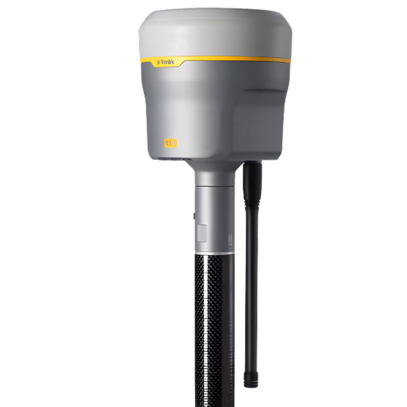
Trimble R980 R980 R980
Seamless connectivity. Total confidence.
The Trimble® R980 GNSS system unlocks peak accuracy and productivity for land surveyors with proven GNSS performance. Overcoming challenging GNSS conditions and excelling in remote locations, the R980 is ready to work wherever the job leads you.
Key specifications
Accurately stake out and measure points faster and in more locations with the R980 and dramatically improve your survey productivity.
- 8 mm H/15 mm V Real-time kinematic precision
- RTK + 3mm + 0.15mm/° tilt TIP positioning performance
- 2 cm H/3 cm V CenterPoint® RTX precision
- 450/900 MHz Dual-band UHF radio
- 4G LTE Cellular modem
- 1.13 kg / 11.9 cm x 13.6 cm Lightweight & compact
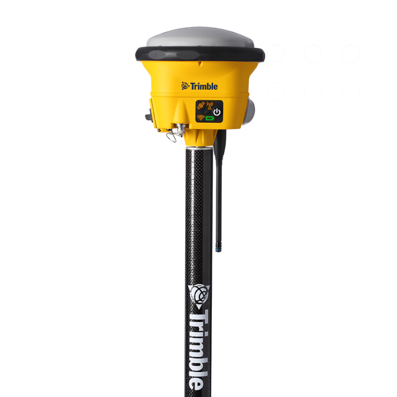
Trimble R780 R780 R780
Freedom to work your way.
The Trimble® R780 GNSS receiver allows you to choose your configuration and scale up by adding additional features. With robust GNSS positioning technologies, trust this ultra-durable receiver to boost your productivity and flexibility in any environment.
Key specifications
Get precise and reliable results with the R780, with continuous coverage and flexible configurations to meet your changing survey needs.
- Configurations Base & rover, rover or base
- Real-time kinematic 8 mm H/15 mm V
- TIP positioning performance RTK + 3mm + 0.15mm/° tilt
- CenterPoint RTX 2 cm H/3 cm V
- Ultra-rugged IP68/MIL-STD-810G
- Dual-band UHF Radio 450/900 MHz
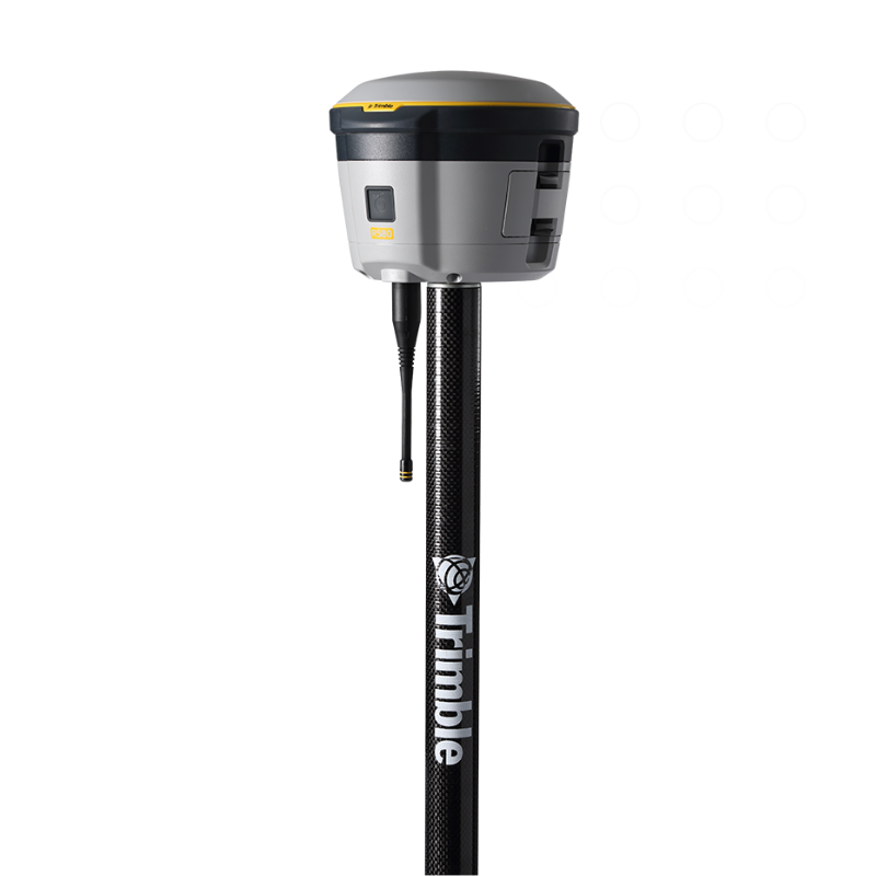
Trimble R580 R580 R580
Proven, reliable positioning
Depend on the Trimble® R580 GNSS system to keep you working with survey precision. Powered by the industry-leading Trimble ProPoint® GNSS engine, this everyday integrated receiver delivers greater productivity and reliable accuracy in more places.
Key specifications
The Trimble R580 GNSS system is a dependable, everyday integrated receiver for survey-grade workflows.
- 10 mm H/20 mm V Maximum precision
- 2 cm H/3 cm V CenterPoint RTX precision
- Quick setup One-button start-up and cable-free
- 450 MHz UHF radio (receive only)
- IP65/MIL-STD Ruggedness
- iOS, Android, Windows 10 Platform support
GNSS systems
Integrated and modular GNSS systems for surveying and mapping.
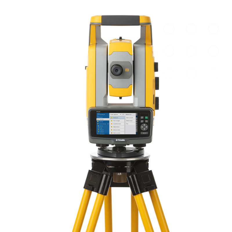
Total Stations
- Home
- PRODUCT LINES
Scanning, robotic, Autolock® and mechanical total stations.
Powered by industry-leading technologies, surveyors around the world trust our high-performance total station solutions for maximum productivity. Streamline your workflows and deliver top quality with precision technologies that meet the needs of your industry.
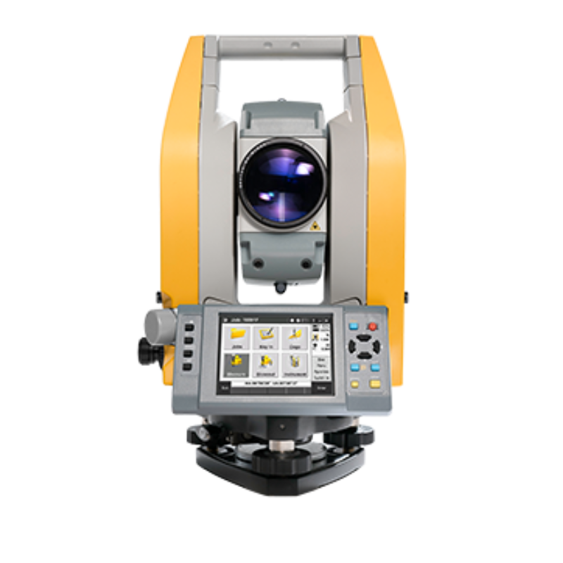
Trimble C5 HP C5 HP C5 HP
What you need for the job you do.
Measure jobsites more precisely under any tough field condition. Trimble® C5 HP mechanical total station is rugged, has an extended battery life and makes you more productive with a smaller, more high-precision EDM beam. It’s the perfect total station for all surveyors.
Key specifications
Rugged but easy to use, this total station is ideal for the accuracy and precision needed for direct reflection (DR) measurements.
- Accuracy 1″, 2″, 3″ or 5″
- Prism accuracy 1 mm + 1.5 ppm Prism/2.0 mm + 2 ppm DR
- Range 3,000 m Prism/500 m DR
- Weight 4.4 kg
- Tilt sensor Dual axis
- Operating temperature -20°C to + 50° C
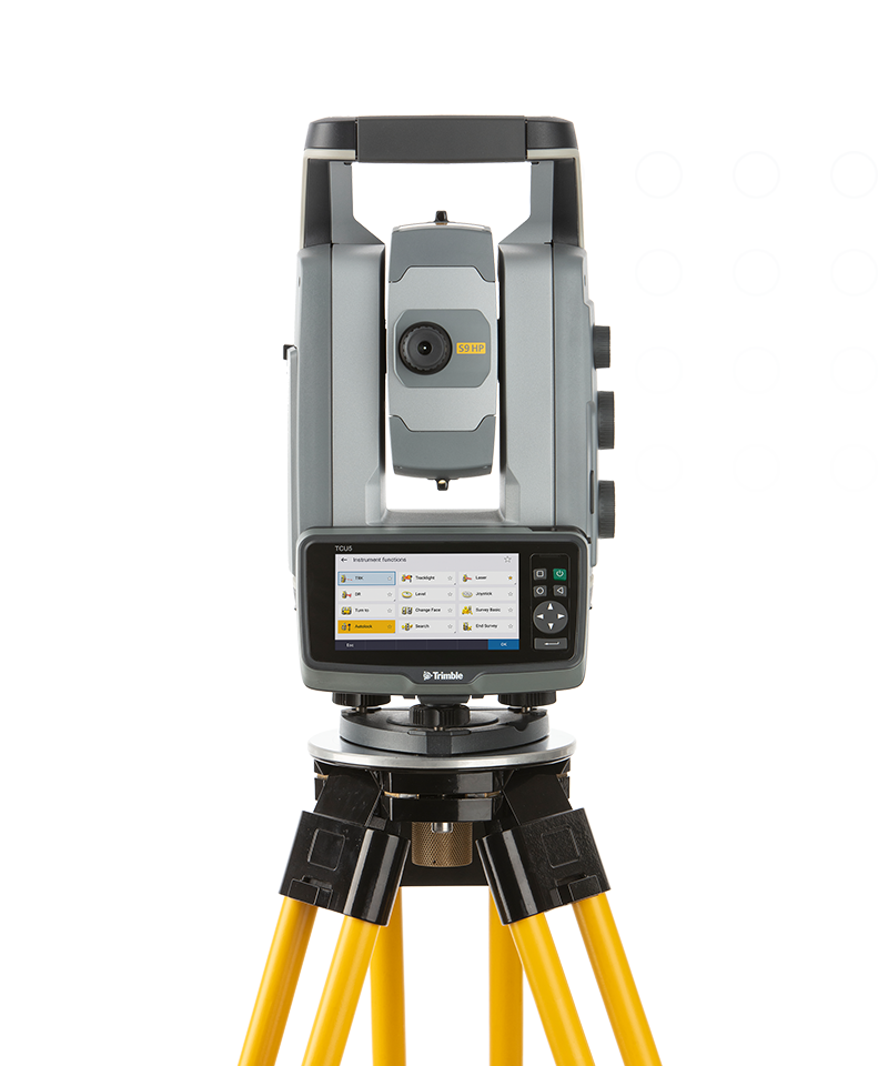
Trimble S9 HP Autolock S9 HP Autolock S9 HP Autolock
Precision you need to succeed.
The Trimble® S9 HP Autolock® total station can easily tackle demanding jobs in monitoring, tunneling or other specialized applications. Autolock technology stays locked onto your prism, intelligently tracking it around the site, and with HP, achieve the highest level of accuracy.
Key specifications
Count on S9 HP Autolock to get difficult jobs done right. This total station provides top-of-line accuracy and reliability.
- Angular accuracy 0.5″ or 1″
- EDM technology DR HP
- EDM accuracy 0.8 mm + 1 ppm Prism/3.0 mm + 2 ppm DR
- Maximum range 7,000 m
- Technology standard on all models Autolock, Magdrive, SurePoint, Active Tracking
- Model-dependent features FineLock, Long Range FineLock, Tracklight, VISION
Trimble S5 Autolock S5 Autolock S5 Autolock
The no-nonsense workhorse.
Trimble S5 Autolock® total station makes survey work easier and faster, allowing you to complete more jobs. This total station locks in on your survey prism, reducing manual aiming time and errors.
Key specifications
Advanced optics provide you with top results. Capture highly-accurate survey data the first time, and reduce trips back to the jobsite for rework.
- Angular accuracy 1″, 2″, 3″, or 5″
- EDM technology DR PLUS
- EDM accuracy 1.0 mm + 2 ppm Prism/2.0 mm + 2 ppm DR
- Maximum range 5,500 m
- Technology standard on all models Autolock, Magdrive, SurePoint
Total stations
Scanning, robotic, Autolock® and mechanical total stations.
Laser Scanning
- Home
- PRODUCT LINES
Terrestrial 3D laser scanning and imaging systems.
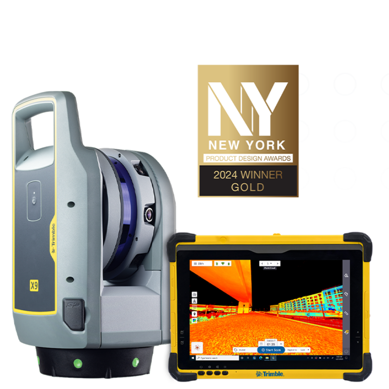
Trimble X9 3D X9 3D X9 3D
The power to do more, on your terms.
Measure jobsites more precisely under any tough field condition. Trimble® The Trimble® X9 3D laser scanning platform leverages proven Trimble technology to deliver the range, accuracy, speed and sensitivity you need to do more. With flexible licensing plan options, choose the scanning functionality that fits your project needs.
Key specifications
Our most versatile laser scanner, offering intermediate range, high accuracy and short scan times with higher sensitivity for peak performance.
- Scan speed Up to 1000 kHz
- Scan range 0.6 m to 150 m
- Scan times < 1 min to 6 min
- Auto-calibration No targets or user interaction for accuracy on every scan
- Self-leveling <3″ with tilt compensation range of ±10°
- Environmental protection IP55
- Operating temperature -20°C to +50°C (–4°F to 122°F)
- Ease of use Intuitive Trimble Perspective workflows
- Licensing plans Adjust your license to your needs
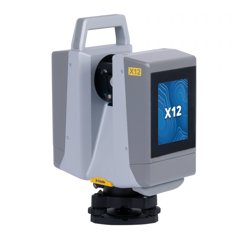
Trimble X12 X12 X12
Enhance your perspective.
The Trimble® X12 3D laser scanning system unites the best of both worlds with industry-leading hardware and ultra-efficient Trimble Perspective software for guaranteed peak performance.
Key specifications
The Trimble X12 3D laser scanner combines stunning speed, accuracy, range, and image clarity in one easy-to-use package.
- High resolution point clouds Up to 2.187 million pts per second
- Superior scan range 0.3 m to 365 m ambiguity interval
- Quick, flexible point cloud capture Full dome scans as fast as 23 seconds
- Sharp, clean image acquisition Colorized point clouds, parallax free
- Ease of use Intuitive Trimble Perspective workflows
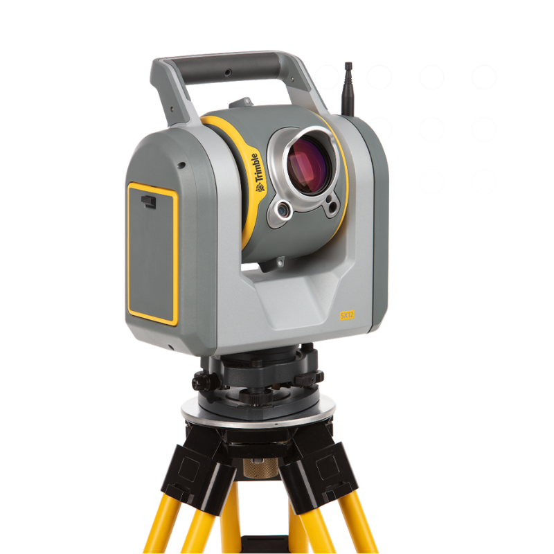
Trimble SX12 SX12 SX12
Engineered for every day.
By combining innovative technology with intuitive functionality the Trimble® SX12 scanning total station saves time and maximizes efficiency.
Key specifications
The combination of a high-accuracy total station and surgically precise scanner lets you save time by capturing detail in key areas, without ever sacrificing accuracy.
- Quick data capture 26,600 points per second (scanning) / 1.6 s total station measuring time (prism mode)
- Highly accurate 1″ angular accuracy & 1 mm + 1.5 ppm prism accuracy
- Precise laser pointer 3 mm diameter spot at 50 m
- EDM accuracy 1.0 mm + 1.5 ppm Prism / 2.0 mm + 1.5 ppm DR
- EDM laser spot diameter 14 mm at 100 m
- Scan range noise 1.5 mm at 200 m
- Vivid, eye-safe laser pointer 3 mm diameter spot at 50 m
Laser scanning
Terrestrial 3D laser scanning and imaging systems.
Mobile Mapping
- Home
- PRODUCT LINES
Vehicle-mounted mapping systems for large-scale mapping projects.
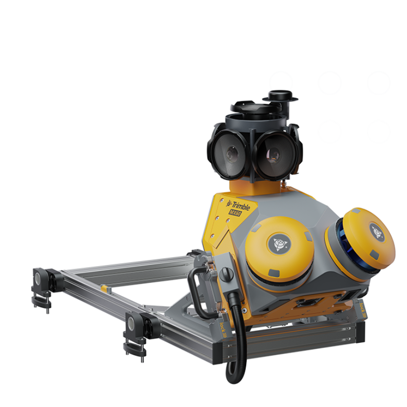
Trimble MX90 MX90 MX90
Achieve new levels of productivity.
The Trimble® MX90 system is part of a complete field-to-finish mobile mapping solution that combines leading-edge hardware with intuitive field software and an integrated office software workflow.
Key specifications
The Trimble MX90 captures rich data for modeling and high-density point clouds, ideal for large survey and engineering projects.
- Laser effective measurement rate Up to 3.6 MHz
- Spherical camera 72 MP (6 x 12 MP)
- Inertial Measurement Unit (IMU) Enhanced GNSS precision
- Weight Sensor unit 37 kg
- IP rating Sensor unit IP64
- Spherical camera 72 MP (6 X 12 MP)
- Planar cameras 2 X 12 MP side facing, 1 X 12 MP backward/downward facing
- Laser effective measurement rate Up to 3.6 MHz
- Scan speed 500 scan/sec
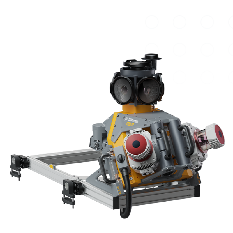
Trimble MX60 MX60 MX60
Each project is a journey. Enjoy the ride.
The Trimble® MX60 mobile mapping system delivers powerful mobile scanning and imaging for asset management. Take control of your data capture and choose from core, pro or premium models to fit your needs and ensure the perfect solution for every project.
Key specifications
The MX60 brings together the best in laser precision, system accuracy and visual performance at high speeds to ensure top-quality data capture.
- Laser effective measurement rate Up to 2000 MHz
- Spherical camera Up to 72 MP
- Embedded Trimble GNSS-inertial system Trimble InFusion+ with ProPoint engine
- Weight Up to 28kg
- IP rating Sensor unit IP64
- Spherical camera Up to 72MP (6 X 12 MP)
- Laser effective measurement rate Up to 2000 kHz
- Scan speed Up to 400 scans/sec
Mobile mapping
Vehicle-mounted mapping systems for large-scale mapping projects.
Data Collectors
- Home
- PRODUCT LINES
Powerful, rugged and designed for the way you collect data.
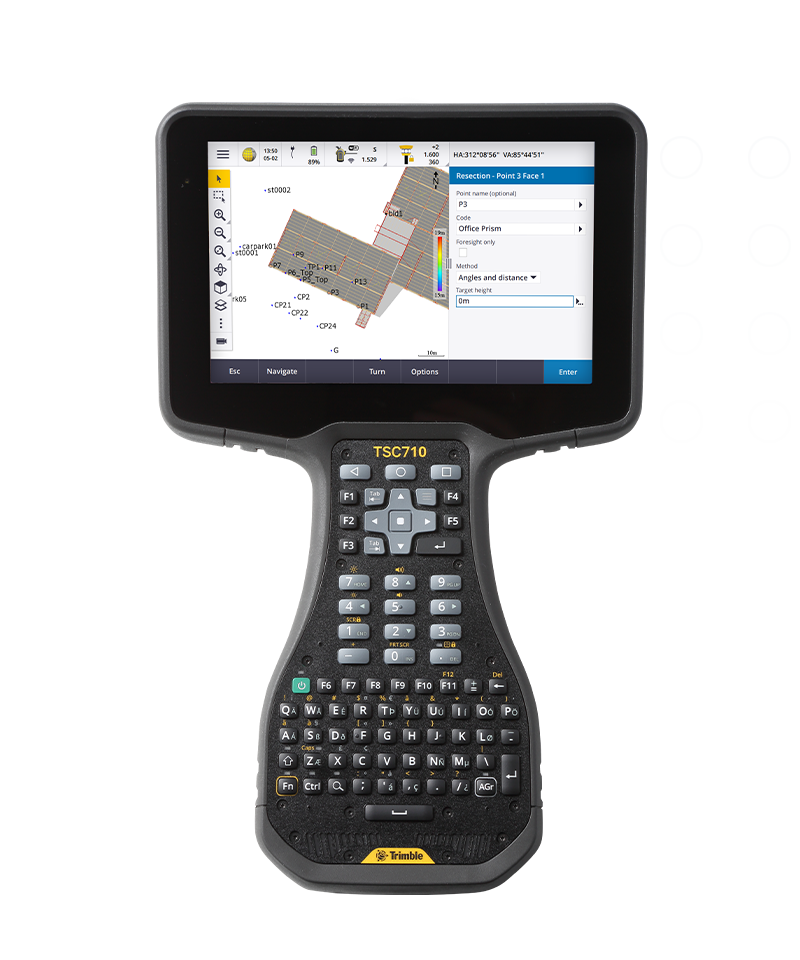
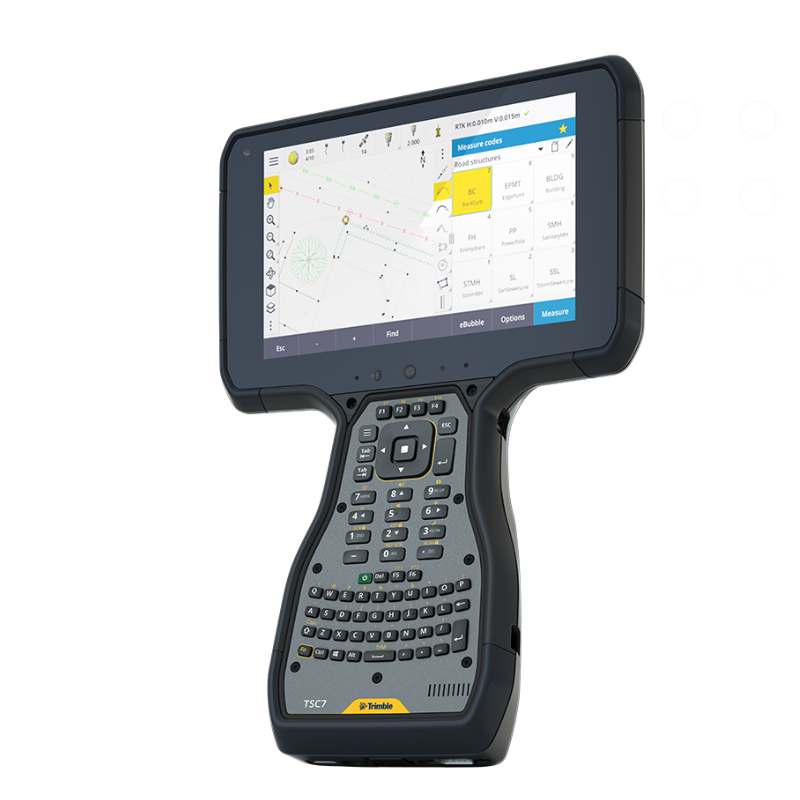
Trimble TSC710 TSC710 TSC710
Connect to a better way to work
The Trimble® TSC710 controller boosts your performance with more memory and power. Its 7-inch screen, full keyboard and robust processing in a compact design ensure seamless field-to-office connectivity with versatile communication capabilities.
Key specifications
Complete your tasks effortlessly with the TSC710. Featuring a large screen, full keyboard and lightweight design, its enhanced features and robust power help simplify your work.
- Anti-glare, 7-inch touch screen Works with finger, stylus or glove
- Backlit alphanumeric keypad Easy data entry in all conditions
- 11 physical function keys More options to speed up jobs
- Android 14 operating system Access Google Play store apps
- Long battery life Internal and removable batteries
- Military-grade specs and IP68 rating Works in all environments
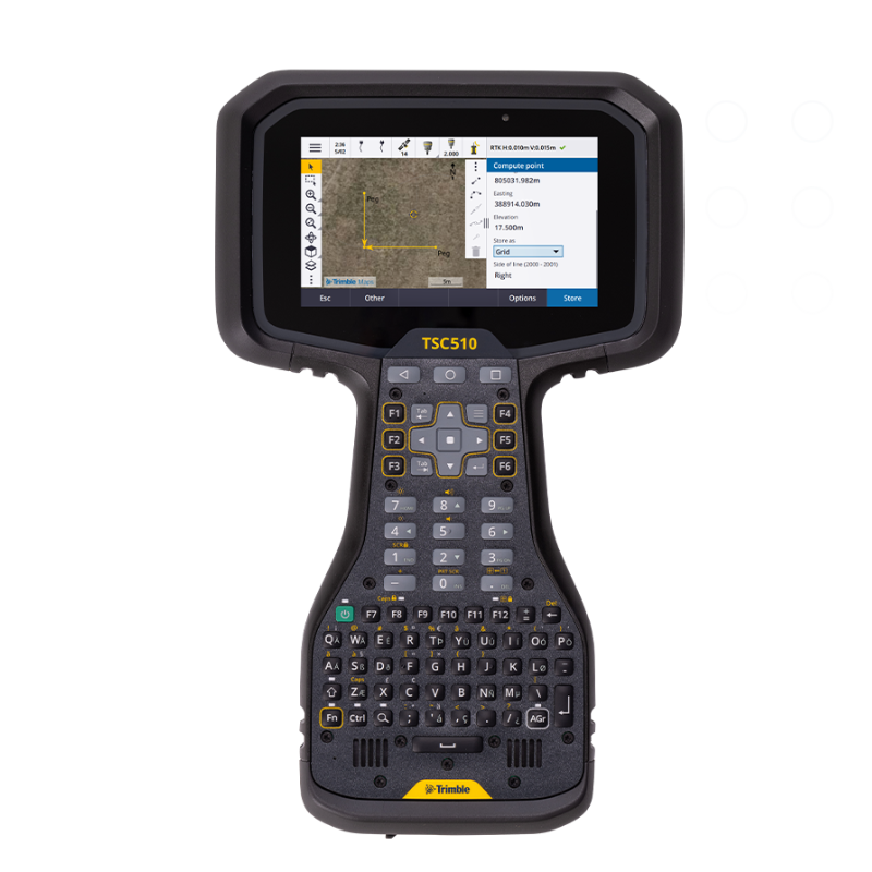
Trimble TSC510 TSC510 TSC510
Connect to a better way to work
Maximize your efficiency with the Trimble® TSC510 controller. Offering seamless connectivity, dependable power and exceptional durability, this top-tier controller is engineered to handle your toughest tasks.
Key specifications
Engineered for the field, the TSC510 combines lightweight design, robust power and enhanced features to ensure efficient and effortless task completion.
- Anti-glare, 5-inch touch screen Works with finger, stylus or glove
- Backlit alphanumeric keypad Easy data entry in all conditions
- 12 function keys More options to speed up jobs
- Android Quick Share Rapid file transfers with nearby Android
- Long-lasting life Internal and removable batteries
- Military-grade specs and IP68 rating Works in all environments
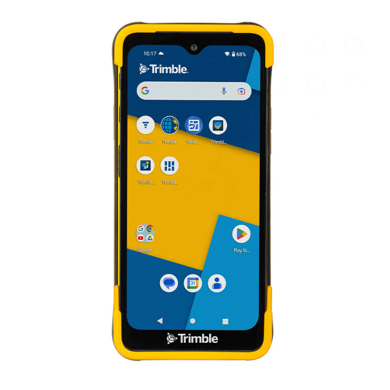
Trimble TDC6 TDC6 TDC6
Effortless flexibility.
The Trimble® TDC6 data collector is a powerful, versatile and cost-effective field data collection solution for surveying and mapping professionals. Use the TDC6 standalone as a GIS data collector, paired with a GNSS receiver or as an onboard total station controller.
Key specifications
With an intuitive Android™ operating system, 5G connectivity and sleek design, the TDC6 handles field work with ease.
- 287 g/10 oz Lightweight, slim form factor
- Android 12 OS Secure and upgradeable
- Worldwide 5G Integrated cellular data
- 9 hour battery life Easy battery hot-swapping
- 6.3 inch screen Sunlight readable display
- IP67/MIL-STD-810G Rugged and durable
Data collectors
Powerful, rugged and designed for the way you collect data.
Augmented Reality
- Home
- PRODUCT LINES
- Trimble SiteVision
Trimble SiteVision, Instant visualization for immediate insights.
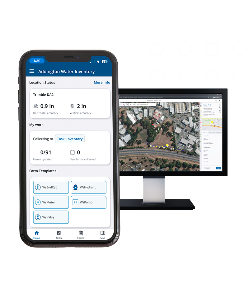
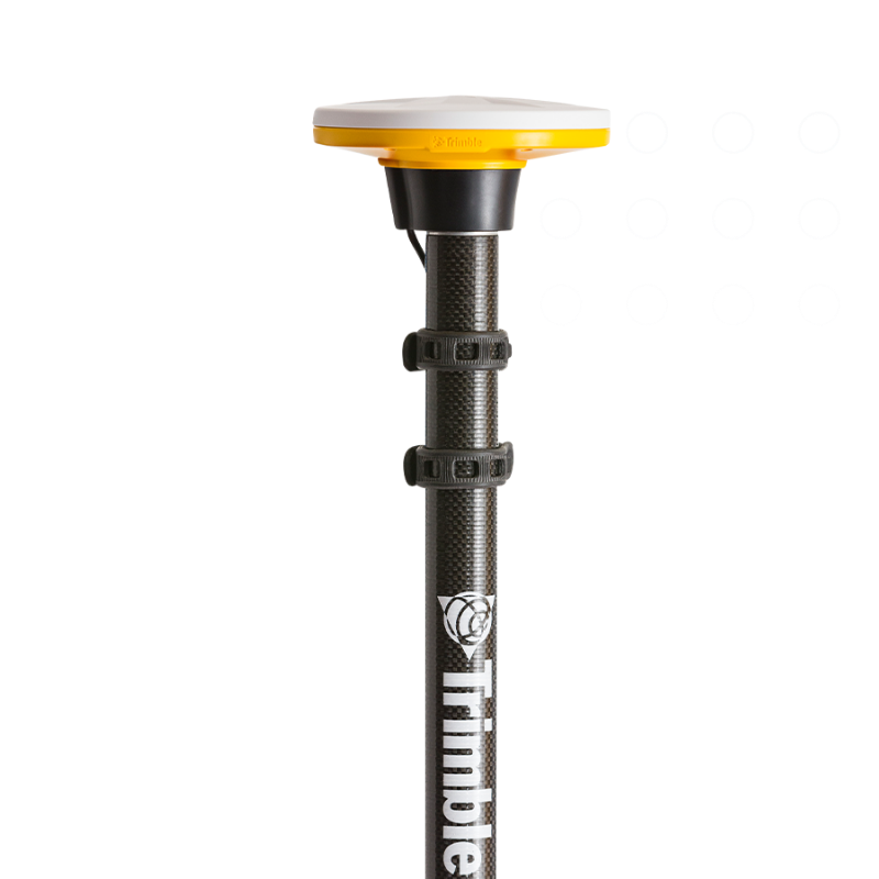
Trimble DA2 DA2 DA2
Simply precise.
Powered by the Trimble® Catalyst™ GNSS positioning service, the DA2 receiver, combined with a Catalyst service subscription, delivers centimeter to sub-meter accuracy to location-enabled Android and iOS field apps and workflows.
Key specifications
The DA2 combined with the Trimble Catalyst positioning service simplifies access to precise positioning workflows on your phone or tablet.
- Scalable precision RTK centimeter to sub-meter
- Multi-frequency capable L1/L2/L5/MSS
- Satellites All GNSS constellations supported
- Connect to Android & iOS devices Via Bluetooth to any location app
- Small & lightweight 128 x 55 mm/330 g (<12 oz)
- Ruggedness MIL-STD-810G/IP65
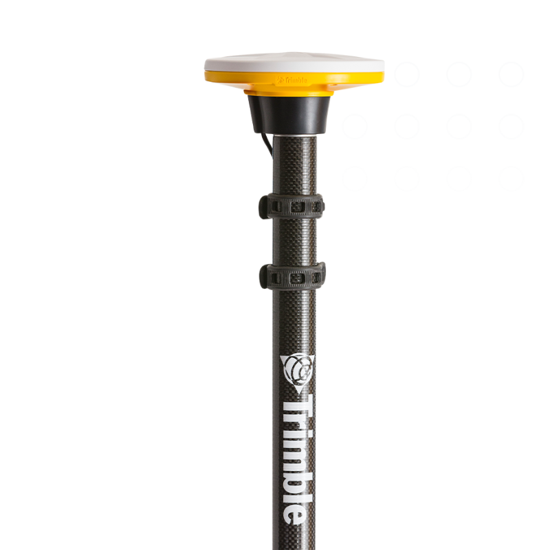
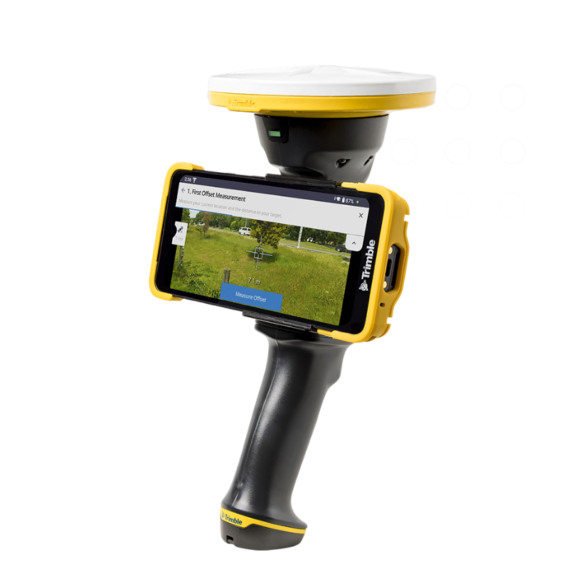
Trimble HPS2 HPS2 HPS2
Supercharge your phone with GNSS and an EDM.
The Trimble® HPS2 handle combines the Trimble DA2 GNSS receiver with an EDM (electronic distance measurement). Compatible with data collection and visualization apps, it leverages modern smartphone cameras and sensors to be a lightweight and flexible field tool.
Key specifications
The HPS2 handle includes a GNSS receiver and EDM technology and pairs with Trimble field software to enable in-field data viewing and data collection.
- Android or iOS Compatible with smartphones
- 1 cm H/2 cm V Real-time kinematic accuracy
- ± 3 mm EDM distance accuracy
- Corrections Catalyst GNSS positioning service
- Wireless connectivity Bluetooth
- Device mount Magnetic steel plate
- Battery Replaceable, rechargeable battery
Augmented reality
Powerful, rugged and designed for the way you collect data.
Digital levels
- Home
- PRODUCT LINES
Trust your measurements.
The Trimble® DiNi® level helps you be more productive by measuring heights significantly faster than with conventional automatic leveling, even in low lights. Eliminate errors and reduce rework with this digital height measurement sensor.
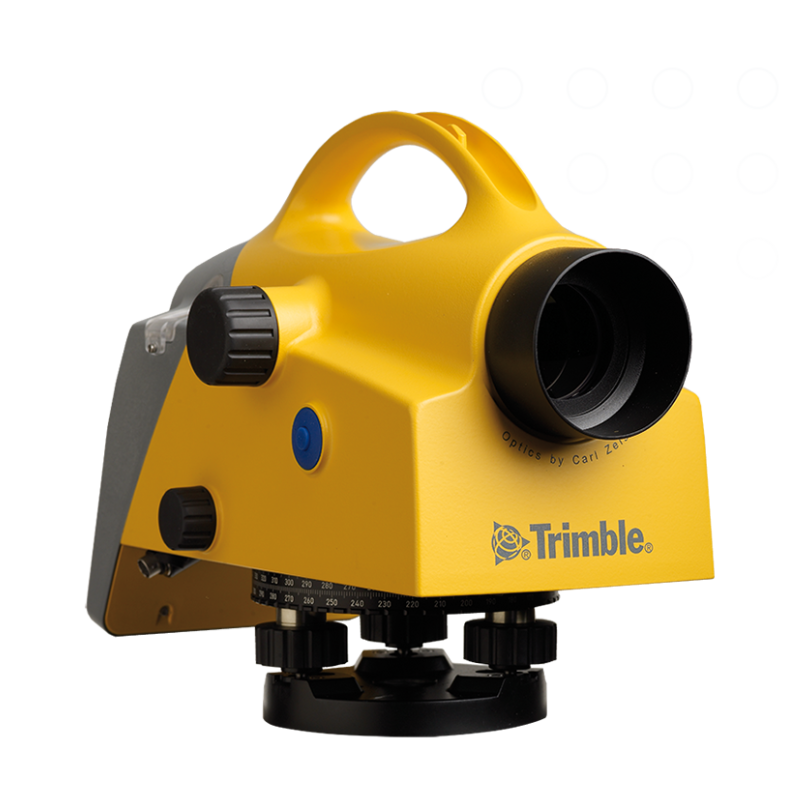
Trimble DiNi DiNi DiNi
Trust your measurements.
The Trimble® DiNi® level helps you be more productive by measuring heights significantly faster than with conventional automatic leveling, even in low lights. Eliminate errors and reduce rework with this digital height measurement sensor.
Key specifications
Collect height measurements accurately and in any condition. The DiNi level has features you can count on.
- Level accuracy 0.3 mm or 0.7 mm
- Electronic measurement range 15 m-100 m
- Graphical display 240 x 160 pixel monochrome
- Operating time 3 days without illumination
- Operating temperature -20 to +50° C
- Dust and waterproofing IP55
Digital Levels
Trust your measurements.
Field Software
- Home
- PRODUCT LINES
Field software to maximize your workflows.
Optimized for specific workflows—from surveying, 3D laser scanning and GIS asset data collection to specialized applications—Trimble field software enables consistent and standardized results and faster deliverables. Stay connected to the office while improving productivity, whatever your field work requires.
Trimble Access Access Access
Designed to support the way surveyors work
A leading field software used by professional surveyors around the world, Trimble® Access™ software delivers functionality that supports efficiency, accuracy and ease of use with simplified workflows.
Our subscription plans make it easier to start and scale with Trimble Access.
With lower upfront costs, our subscription plans allow you to use and scale your licenses flexibly while you benefit from the latest updates.
Key specifications
- Powerful COGO routines Convenient one-tap feature coding
- Integrate with BIM models View & use IFC and TrimBIM files
- Trimble Maps Up-to-date background maps help identify key features near a survey mark
- Horizontal tilt offset Measure hard-to-reach locations
- Underground utility locator Locate buried assets
- Split screen map & form layout Interact with map & form fields
Trimble TerraFlex TerraFlex TerraFlex
Streamline your data collection.
Unite easy, intuitive field data capture with high-accuracy GNSS positioning with Trimble® TerraFlex® software for a single, streamlined solution. Whether it’s time to modernize or you’re starting from scratch, TerraFlex checks all the boxes.
How it works
Streamline data collection projects and simplify their deployment across your entire organization.
Features
- Customizable form templates Easy-to-use template builder
- Cloud synchronization Efficient data flow from the field
- Offline GNSS corrections Automated GNSS post-processing
- Remote feature capture Simplified laser offset workflow
- Update and maintain data Import and update existing data
- Data collaboration Export and share captured data
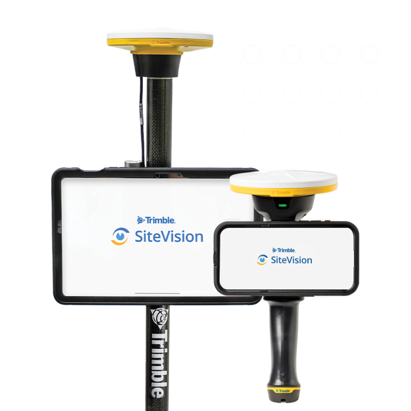
Trimble SiteVision SiteVision SiteVision
Instant visualization for immediate insights.
Trimble® SiteVision® is a real-time, in-field visualization software for collaborating on project progress and detecting design changes or conflicts. Choose your hardware configuration to collect images, GNSS points, EDM points or LiDAR scans.
Key specifications
Use SiteVision on any smart device to bring your project to life.
- Centimeter-accuracy With Trimble Catalyst DA2 GNSS
- Platform compatibility Android and iOS phones or tablets
- Lightweight and portable Pole or handle mounted operation
- Cloud-based Trimble Connect integration
- Fully textured models in 3D Plan view or cross-section
- Compatible file formats Trimble and open industry standard
Field Software
Powerful, rugged and designed for the way you collect data.
Office software
- Home
- PRODUCT LINES
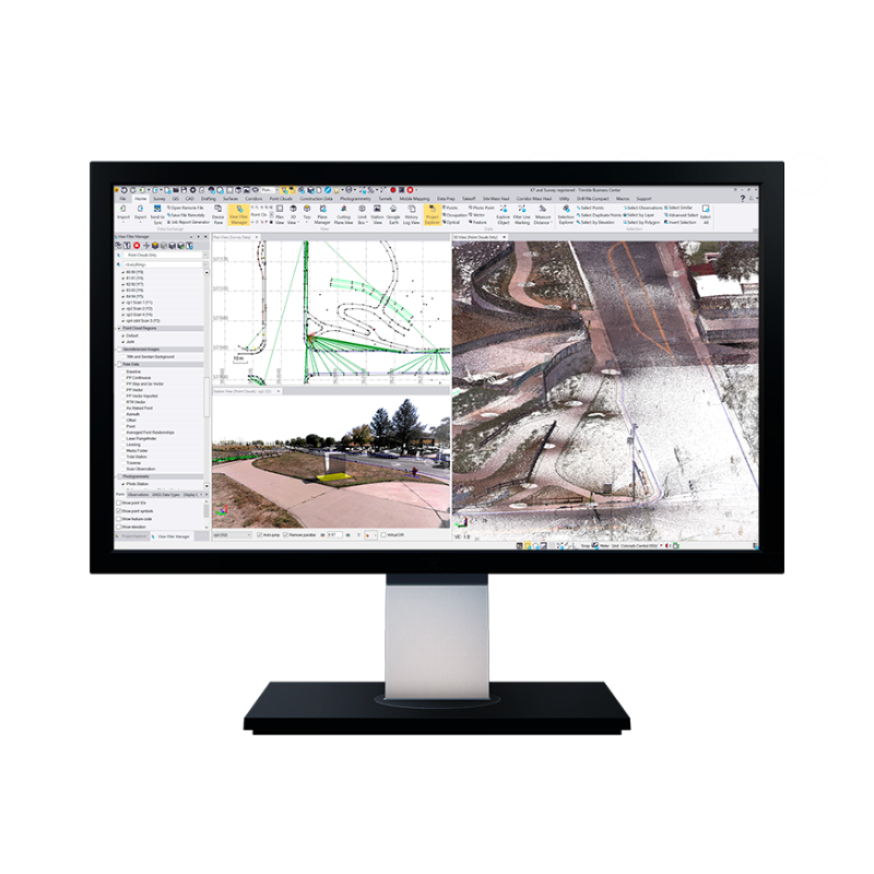
Trimble Business Center Business Center Business Center
Field-to-finish survey CAD software.
Trimble® Business Center (TBC) software enables surveyors to transform field data from GNSS receivers, total stations, laser scanners, mobile mapping systems, drones and more into high-quality, actionable information and client deliverables.
Licensing on your terms
TBC subscription plans come with lower upfront costs and provide you with the flexibility to use and scale your licenses as needed, and benefit from the latest software updates. Choose the plan that best suits your needs, or consider one of our perpetual licensing options.
Features
- Data prep Create constructible models
- Field data adjustment Reduction and post-processing tools
- GIS Link attributes & geometry to Esri
- Point clouds & scanning Extract info and classify regions
- Surfaces Dynamically link & update
- Takeoff Quantities for planning & payment
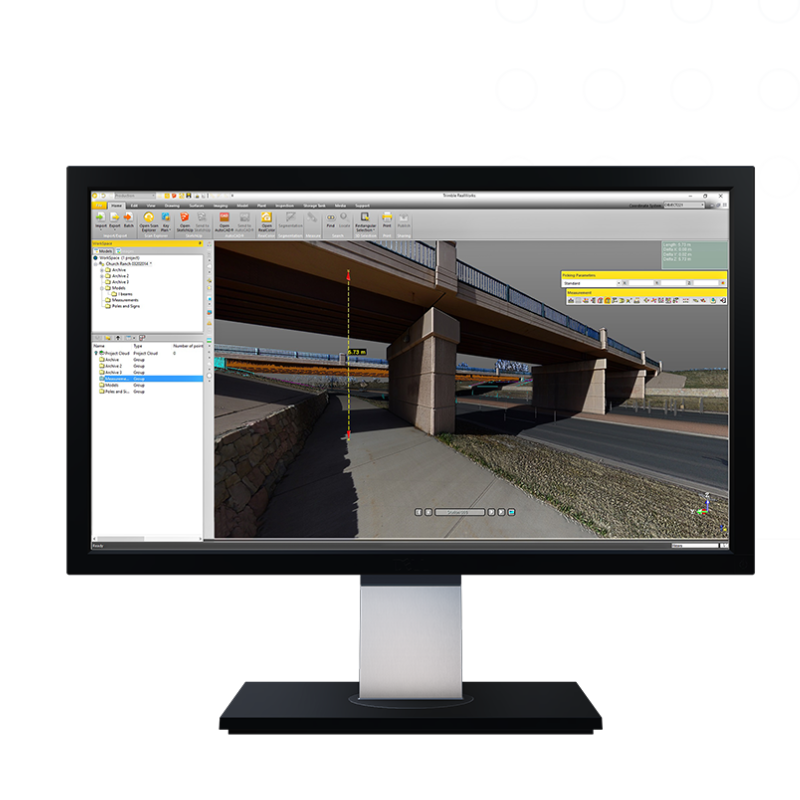
Trimble RealWorks RealWorks RealWorks
Automated, point cloud workflows—fast.
Import point cloud data from virtually any source, then quickly process, analyze and create high-quality deliverables with the automated tools and point cloud-specific workflows of Trimble® RealWorks™ software.
Licensing on your terms
With lower upfront costs, our subscription plans allow you to use and scale your licenses flexibly while you benefit from the latest updates.
- Affordable Lower upfront costs
- Flexible Built around your needs
- Always up-to-date Benefit from enhancements
Features
- Specifically designed Point cloud processing & analysis
- Complete solution Register, analyze, model & create
- Create deliverables With data from any source
- Automated tools Registration & point cloud cleanup
- Tools & workflows Made for point cloud processing
- For any project Access all the processing tools
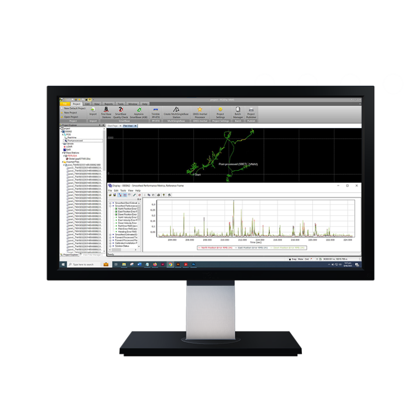
Trimble Applanix POSPac MMS Applanix POSPac MMS Applanix POSPac MMS
A start-to-finish workflow for direct georeferencing.
Trimble® SiteVision® is a real-time, in-field visualization software for collaborating on project progress and detecting design changes or conflicts. Choose your hardware configuration to collect images, GNSS points, EDM points or LiDAR scans.
Features
- Operating System Windows 10 support
- Processor 64-bit processing
- License Floating license support
- Automatic base station survey Static PP-RTX
Office software
Produce the highest quality deliverables with confidence.
Cloud software
- Home
- PRODUCT LINES
Trimble Reality Capture Reality Capture Reality Capture
Unlock your reality capture data.
The Trimble® Reality Capture platform service enables users to collaborate, share, store and manage large amounts of reality capture data in the cloud. Seamlessly link data and share with non-technical stakeholders easily in Trimble Connect.
Reality Capture on your terms
The platform service is available in a flexible data usage model, meaning you only pay for what you need. Choose from three data usage plans or customize your plan to meet the unique needs of your business.
Features
- Central source of data Increases workflow efficiency
- Unlocking reality capture at scale Built to handle data of all sizes
- Secure cloud storage Powered by Microsoft Azure
- Leveraging one Trimble ecosystem Across all stakeholders
- Trimble Connect web-based interface Data access across diverse teams
- Simpler visualization & navigation Experience complex data intuitively
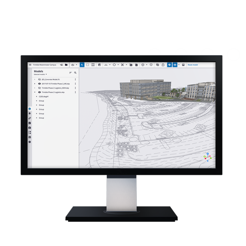
Trimble Connect Connect Connect
Collaboration made easy.
Connect the right people to the right data at the right time with the Trimble Connect® cloud-based common data environment (CDE) and collaboration platform.
Licensing on your terms
Sign up for a free personal account or unleash your team’s full collaborative potential with a Business or Business Premium license.
- Personal Get the first project on us!
- Business Unlimited projects and more
- Business Premium Advanced capabilities and more
Features
- Plan Streamlined data management
- Collect Manage field work better
- Store Single source of truth
- Publish Efficient communication
- View Cross-domain collaboration
- Collaborate Easy to use environment
Cloud software
Collaboration made easy.
Monitoring
- Home
- PRODUCT LINES
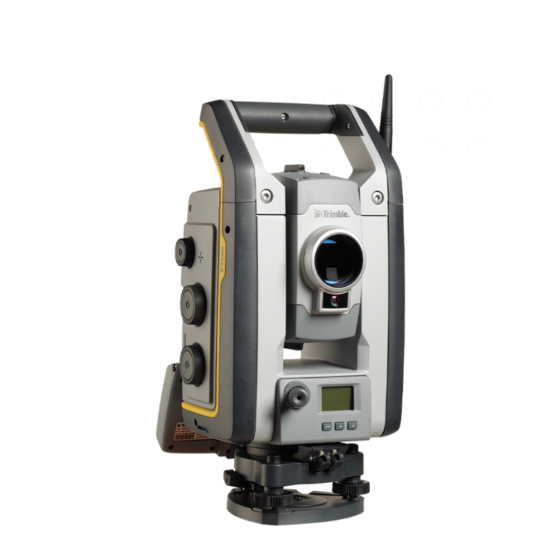
Trimble S7 S7 S7
A powerful instrument for surveyors.
As a feature-rich robotic total station with an included radio, Trimble® S7 total station enables single-user operation. It’s the only instrument you need on the jobsite, maximizing your efficiency every day.
Key specifications
Collect survey data from a distance—and alone—with this robust total station that meets your expectations for accuracy and power.
- Angular accuracy 1″, 2″, 3″, or 5″
- EDM technology DR PLUS
- EDM accuracy 1.0 mm + 2 ppm (Prism)/2.0 mm + 2 ppm (DR)
- Maximum range 5,500 m
- Technology standard on all models Autolock, Magdrive, SurePoint, Active Tracking
- Model-dependent features FineLock, VISION, SureScan
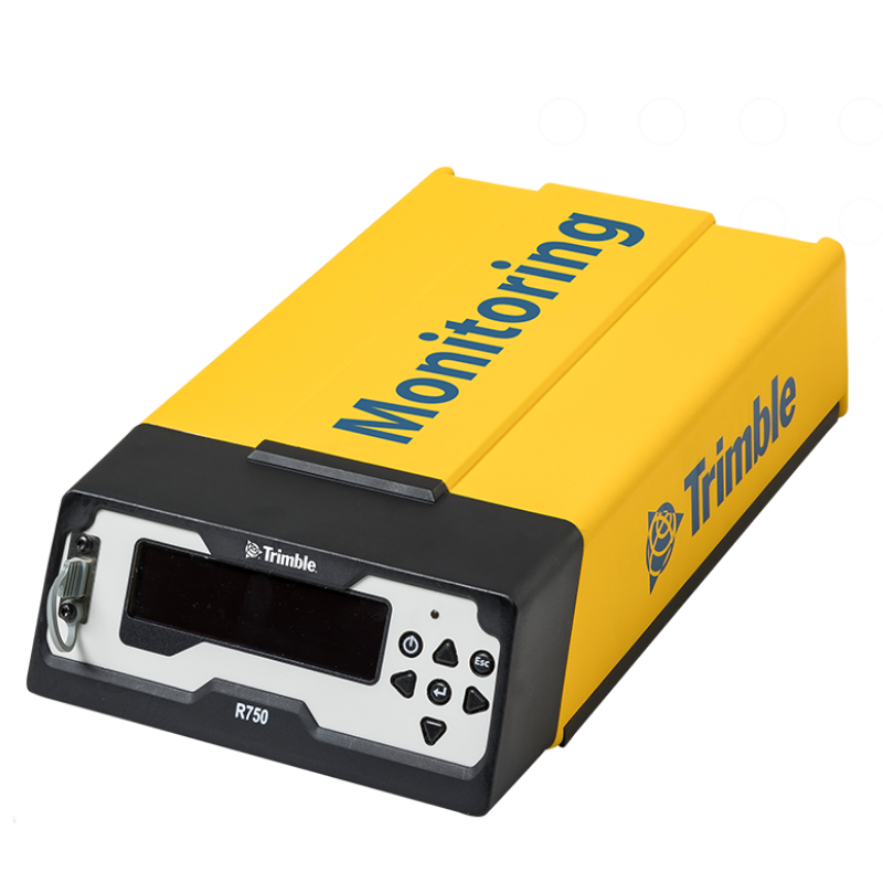
Trimble R750 MON Model 2 R750 MON Model 2 R750 MON Model 2
High frequency, high accuracy monitoring.
The Trimble® R750 MON Model 2 GNSS receiver incorporates the latest industry-leading positioning technology from Trimble, along with modern communications capabilities, in a rugged form factor that is ready to be deployed on automated monitoring projects.
Key specifications
Benefit from a high frequency, high GNSS receiver that connects seamlessly to Trimble 4D Control™ for automated monitoring without an external modem.
- 8 mm H / 15 mm V RTK precision
- Up to 20Hz High frequency position rate
- 4G LTE Modern Cellular
- 8 GB Internal Data storage
- External Zephyr 3 Base antenna Comes with antenna and accessories
- Operating temperature -40C° to +65C° Any environment
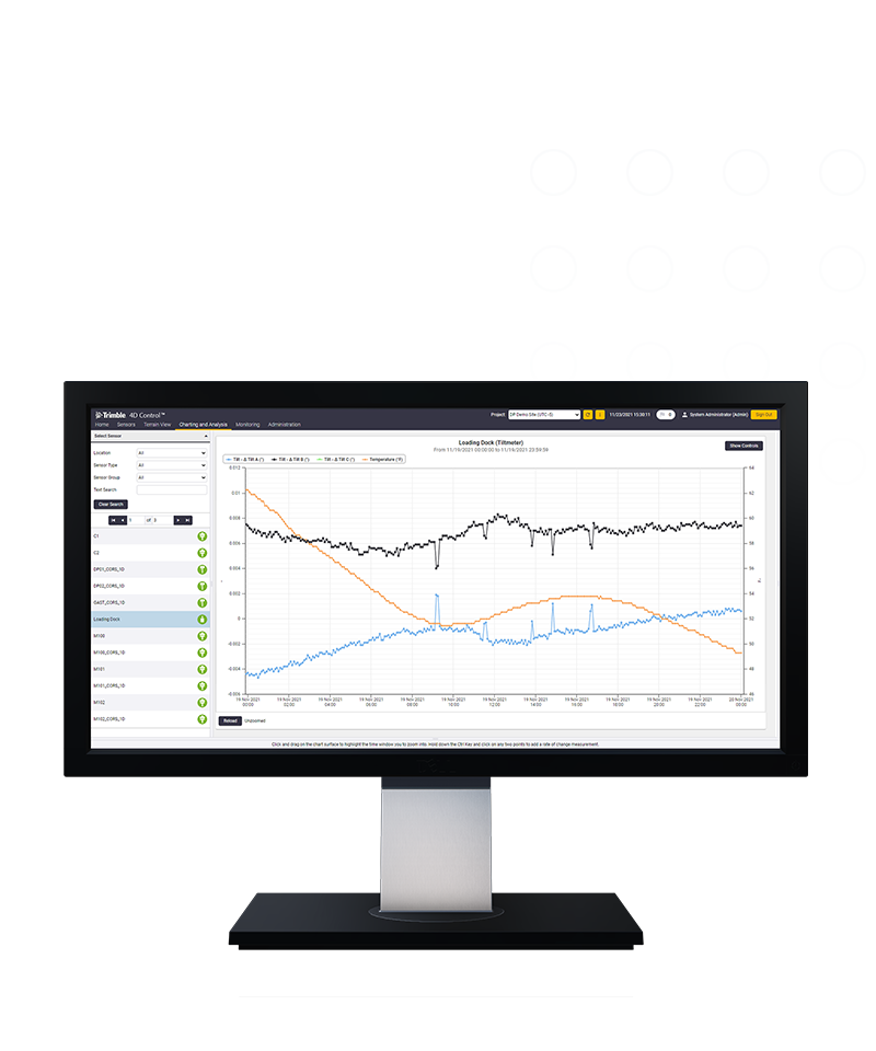
Trimble 4D Control 4D Control 4D Control
Level up your monitoring system.
Elevate your monitoring with Trimble® 4D Control (T4D) software. Deploy this automated movement detection solution to make better-informed decisions. Easily configure a range of sensors, manage monitoring data and share real-time analysis with stakeholders.
Industries and applications
The future of your work.
Trimble solutions facilitate high-quality, productive workflows and data exchange, driving value for a global, diverse user base.
Features
- Scalable conditional alarming Movement or system outages
- Comprehensive analysis Customizable data visualization
- Processing engines Real-time and post-processed
- Network adjustment Combined and integrated
- Alignment integration Relate movement to design alignment
- Contextual visualization Background maps and imagery
Monitoring
Automated, continuous real-time monitoring and alerts.
Real Time Networks
- Home
- PRODUCT LINES
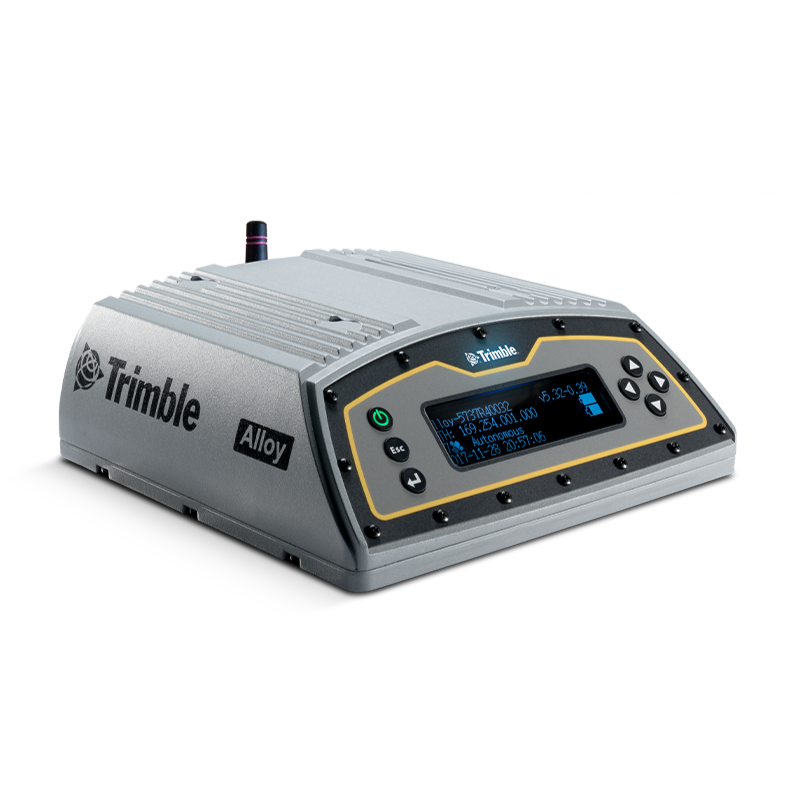
Trimble Alloy GNSS CORS receiver Alloy GNSS CORS receiver Alloy GNSS CORS receiver
Leveraging Trimble RTX™ precise point positioning
With tough IP68 housing and modernized satellite tracking, Trimble Alloy can be used in Real-Time Networks (RTN) as a Continuously Operating Reference Station (CORS) or as a campaign receiver.
Key specifications
- Unrivaled in the market for its rugged design, featuring extensive channels, ports and a quad core processor for an unmatched performance and longevity.
- Powerful GNSS tracking technology provides impressive tracking and processing power
- Modern GNSS tracking supports all known and planned GNSS constellations
- Reversible angled display and multiple connectors for easy setup and monitoring in a variety of environments
- Dual hot-swappable batteries with integrated charging and IP68 certification makes Alloy ready for any environment
- Firmware for life—keep your Alloy receiver up-to-date with the latest features, enhancements and security updates
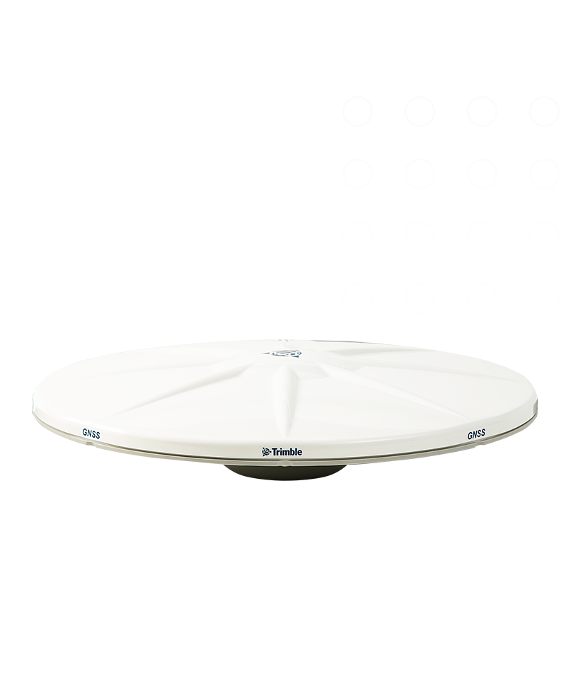
Trimble Zephyr 3 Geodetic Zephyr 3 Geodetic Zephyr 3 Geodetic
The Trimble® Zephyr™ 3 Geodetic antenna utilizes the Trimble Stealth ground plane to function optimally in areas with high multi-path interference. It is protected by weather-resistant materials and a low profile design.
Specifications
- Comprehensive GNSS support, including GPS, GLONASS, Galileo, Beidou, QZSS and NavIC
- Robust low-elevation satellite tracking
- Minimized multipath
- Sub-millimeter phase center repeatability
- Improved signal reception in harsh signal environments
- Japanese LTE filtering
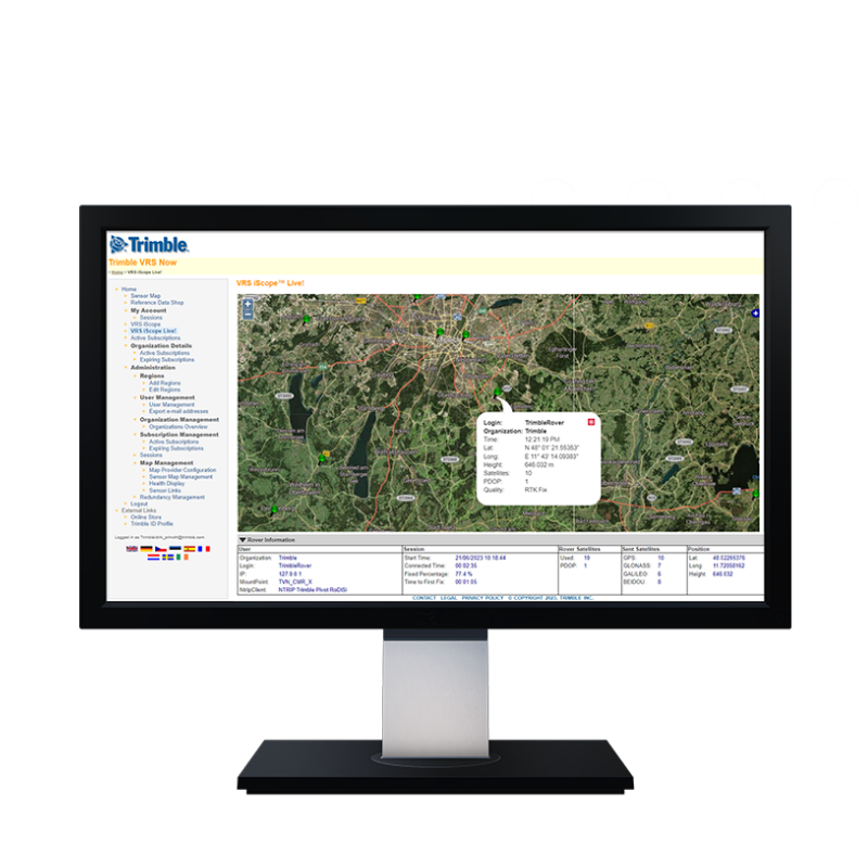
Trimble Pivot Platform Pivot Platform Pivot Platform
Trimble® Pivot® Platform software is GNSS CORS network software for managing GNSS reference stations and generating real-time corrections.
Features
- Common platform for improved system performance
- Fully integrated architecture for simplified system configurations
- Single platform to maintain version consistency across multiple Apps
- Shared components may be updated across multiple Apps
- Minimizes the time and effort to deploy software updates
- Scalable and flexible, Trimble Pivot Platform reduces complexity while increasing productivity
Real Time Networks
We design, build and operate real-time networks.
Public Safety and Forensics
- Home
- PRODUCT LINES
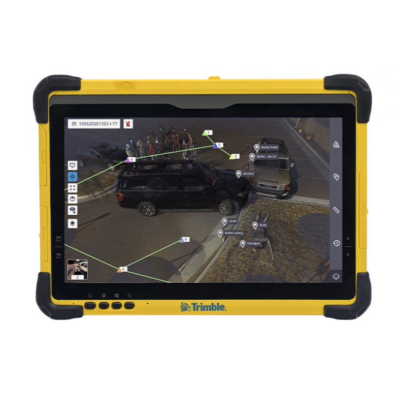
Trimble Forensics Capture Forensics Capture Forensics Capture
Guided workflows for efficient scene mapping.
Trimble® Forensics Capture field software is a powerful yet intuitive data collector solution that simplifies scene evidence gathering and enables a seamless transition to Trimble Forensics Reveal desktop software for in-depth analysis.
Key specifications
- Point cloud georeferencing Create in the field
- In-field documentation Scan all field markers and more
- Scanner operation Remote control or cable
- Trimble Registration Assist Scan data reports and registration
- Data interaction 2D, 3D, and station views
- Multiple GNSS connection options RTK, Trimble RTX or base and rover
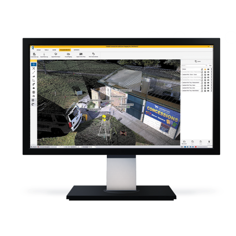
Trimble Forensics Reveal Forensics Reveal Forensics Reveal
Take reconstruction to an entirely new level.
The Trimble® R750 MON Model 2 GNSS receiver incorporates the latest industry-leading positioning technology from Trimble, along with modern communications capabilities, in a rugged form factor that is ready to be deployed on automated monitoring projects.
Key specifications
- Forensics diagramming Build 2D and 3D diagrams
- Forensics analysis tools Bullet trajectory and momentum
- 3D modeling Build custom or from 3D warehouse
- Vehicle spec database Up-to-date vehicle specs
- Create animations 2D and 3D animations on a timeline
- Maintain chain of custody Password-protected, read-only option
Trimble DA2 DA2 DA2
Simply precise.
Powered by the Trimble® Catalyst™ GNSS positioning service, the DA2 receiver, combined with a Catalyst service subscription, delivers centimeter to sub-meter accuracy to location-enabled Android and iOS field apps and workflows.
Features
The DA2 combined with the Trimble Catalyst positioning service simplifies access to precise positioning workflows on your phone or tablet.
- Scalable precision RTK centimeter to sub-meter
- Multi-frequency capable L1/L2/L5/MSS
- Satellites All GNSS constellations supported
- Connect to Android & iOS devices Via Bluetooth to any location app
- Small & lightweight 128 x 55 mm/330 g (<12 oz)
- Ruggedness MIL-STD-810G/IP65
Public Safety and Forensics
Automated, continuous real-time monitoring and alerts.